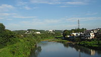
Iruma River
Appearance
| Iruma River | |
|---|---|
 Iruma River in Hannō, Saitama | |
| Native name | 入間川 (Japanese) |
| Location | |
| Country | Japan |
| Physical characteristics | |
| Source | |
| • location | Mount Hannō in Hannō, Saitama |
| • elevation | 1,197 m (3,927 ft) |
| Mouth | |
• location | Arakawa River |
| Length | 63 km (39 mi) |
| Basin size | 721 km2 (278 sq mi) |
The Iruma River (入間川, Iruma-gawa), is a river in Saitama Prefecture, Japan.[1][2] It is 63 kilometres (39 mi) long and has a watershed of 721 square kilometres (278 sq mi). The river rises from Mount Ōmochi in Hannō, Saitama and flows to the Arakawa River at Kawagoe, Saitama.
References
[edit]- ^ Group, Sasai Fossil Forest Research (1984). "Geology of the Sasai Fossil Forest in the Bedrock of Iruma River, Saitama Prefecture, Japan". Bull Saitama Mus Nat. 2.
{{cite journal}}:|last=has generic name (help) - ^ "災害・防災情報:令和元年台風第19号による被害状況等について - 国土交通省". www.mlit.go.jp. Retrieved 2022-11-29.
External links
[edit]35°54′35″N 139°32′43″E / 35.90982°N 139.545139°E
