Mount Lincoln (Colorado)
| Mount Lincoln | |
|---|---|
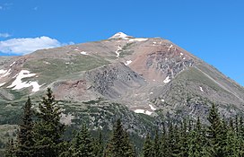
 View of Mt Lincoln from Colorado State Highway 9 | |
| Highest point | |
| Elevation | 14290.6 ft (4355.79 m)[1] NAPGD2022 |
| Prominence | 3862 ft (1177 m)[2] |
| Isolation | 22.5 mi (36.2 km)[2] |
| Listing | |
| Coordinates | 39°21′05″N 106°06′42″W / 39.3514512°N 106.1115668°W[3] |
| Naming | |
| Etymology | Abraham Lincoln |
| Geography | |
| Location | High point of Park County, Colorado, United States[2] |
| Parent range | Highest summit of the Mosquito Range[2] |
| Topo map(s) | USGS 7.5' topographic map Alma, Colorado[4] |
| Climbing | |
| Easiest route | West Ridge: Hike, class 2[5] |
Mount Lincoln is the eighth-highest summit of the Rocky Mountains of North America and the U.S. state of Colorado. The prominent 14,291-foot (4355.79 m) fourteener is the highest summit of the Mosquito Range and the eleventh-highest summit in the contiguous United States. Mount Lincoln is located in Pike National Forest, 5.2 miles (8.3 km) north-northwest (bearing 332°) of the Town of Alma in Park County, Colorado, United States. The summit of Mount Lincoln is the highest point in Park County and the entire drainage basin of the Missouri River. The mountain was named in honor of Abraham Lincoln, 16th President of the United States.[3][2][4]
Climbing
[edit]
Mount Lincoln is typically climbed from the Kite Lake Trailhead, at the end of Park County Road 8. Many climbers attempt to combine the summit of Mount Lincoln with those of Mount Bross and Mount Democrat in one climb.[6] Most routes to the summit are rated class 2.[7]
Access issues
[edit]
Silver was discovered here in 1874.[8]: 56
Mount Lincoln, along with its neighbors Cameron, Democrat and Bross, is pockmarked with old mines, and much of the land is owned privately by mining companies; a large mine still operates in nearby Climax. In the summer of 2005, these landowners denied access to the peaks by hikers and climbers, fearing liability in the case of injury, and citing the particular dangers due to the presence of old mine workings. On August 1, 2006, the town of Alma signed a deal to lease the peaks for a nominal fee, to reduce the potential liability to the owners and free up the peaks for recreational access.[9] The opening of these peaks excludes the summit of Mount Bross since not all of the landowners have given permission for access to the area.[10]
Climate
[edit]| Climate data for Mount Lincoln 39.3494 N, 106.1170 W, Elevation: 13,832 ft (4,216 m) (1991–2020 normals) | |||||||||||||
|---|---|---|---|---|---|---|---|---|---|---|---|---|---|
| Month | Jan | Feb | Mar | Apr | May | Jun | Jul | Aug | Sep | Oct | Nov | Dec | Year |
| Mean daily maximum °F (°C) | 19.1 (−7.2) |
18.1 (−7.7) |
24.2 (−4.3) |
31.3 (−0.4) |
39.7 (4.3) |
50.5 (10.3) |
56.6 (13.7) |
54.2 (12.3) |
48.2 (9.0) |
37.1 (2.8) |
25.6 (−3.6) |
19.3 (−7.1) |
35.3 (1.8) |
| Daily mean °F (°C) | 8.3 (−13.2) |
7.3 (−13.7) |
12.5 (−10.8) |
18.6 (−7.4) |
27.5 (−2.5) |
37.3 (2.9) |
43.6 (6.4) |
41.9 (5.5) |
35.5 (1.9) |
25.3 (−3.7) |
15.3 (−9.3) |
8.8 (−12.9) |
23.5 (−4.7) |
| Mean daily minimum °F (°C) | −2.5 (−19.2) |
−3.4 (−19.7) |
0.8 (−17.3) |
5.9 (−14.5) |
15.2 (−9.3) |
24.0 (−4.4) |
30.6 (−0.8) |
29.7 (−1.3) |
22.8 (−5.1) |
13.6 (−10.2) |
5.0 (−15.0) |
−1.8 (−18.8) |
11.7 (−11.3) |
| Average precipitation inches (mm) | 2.73 (69) |
3.18 (81) |
3.50 (89) |
4.38 (111) |
3.30 (84) |
1.13 (29) |
2.38 (60) |
2.76 (70) |
1.77 (45) |
2.57 (65) |
3.13 (80) |
2.86 (73) |
33.69 (856) |
| Source: PRISM Climate Group[11] | |||||||||||||
See also
[edit]References
[edit]- ^ Ahlgren, Kevin; Van Westrum, Derek; Shaw, Brian (April 2024). "Moving mountains: reevaluating the elevations of Colorado mountain summits using modern geodetic techniques". Journal of Geodesy. 98 29. doi:10.1007/s00190-024-01831-8.

- ^ a b c d e "Mount Lincoln, Colorado". Peakbagger.com. Retrieved January 2, 2016.
- ^ a b "MT LINCOLN". NGS Data Sheet. National Geodetic Survey, National Oceanic and Atmospheric Administration, United States Department of Commerce. Retrieved January 2, 2016.
- ^ a b "Mount Lincoln". Geographic Names Information System. United States Geological Survey, United States Department of the Interior. Retrieved November 14, 2014.
- ^ "Mt. Lincoln Routes". 14ers.com.
- ^ Louis W. Dawson II (1994). Dawson's Guide to Colorado's Fourteeners, Volume 1. Blue Clover Press. ISBN 0-9628867-1-8.
- ^ "Mount Lincoln - Climbing Routes, Photos & Maps". 14ers.com. Retrieved 2024-11-02.
- ^ Voynick, S.M., 1992, Colorado Gold, Missoula: Mountain Press Publishing Company, ISBN 0878424555
- ^ "Alma officials mount trail-access campaign". Denver Post. August 8, 2006.
- ^ "Mount Democrat | Colorado Fourteeners Initiative".
- ^ "PRISM Climate Group, Oregon State University". PRISM Climate Group, Oregon State University. Retrieved October 9, 2023.
To find the table data on the PRISM website, start by clicking Coordinates (under Location); copy Latitude and Longitude figures from top of table; click Zoom to location; click Precipitation, Minimum temp, Mean temp, Maximum temp; click 30-year normals, 1991-2020; click 800m; click Retrieve Time Series button.

